The second you step out of your car at Grafton Notch State Park, you hear it before you see it—the sound of rushing water echoing through a canyon you didn’t know Maine possessed. Old Speck Mountain towers above you, wrapped in morning mist, and the only other people around are a couple of locals and maybe a curious hiker or two. No gift shops. No “Visit Maine!” signs don’t find any hidden gems in Maine. Just rock, water, sky, and the deeply satisfying feeling that you’ve stumbled onto something real.
That’s what I thought when I planned a road trip through Maine last fall, armed with a half-filled tank and a strong suspicion that Maine’s most beautiful corners aren’t the ones with tour buses parked outside. I’ve driven the length of this state—from its southernmost rocks to its wildest north woods—and I kept discovering that the best versions of Maine aren’t found in the headlines or the standard guidebooks. They’re found by turning down roads that don’t make it into the typical itinerary, parking in small lots that never fill up, and hiking to waterfalls that only locals seem to know about.
This guide covers 10 of those places, the ones that deliver the authentic Maine experience without the crowds. These are destinations where you can actually hear yourself think, where the views don’t come with a markup, and where the only person taking your photo is probably you.
Table of Contents
Why Maine Deserves More Attention Than You’d Think
Most people associate Maine with lobster rolls and Acadia National Park—and while both are worth your time, they represent about 5% of what the state actually offers. Maine is the largest New England state, and it’s criminally underexplored. Here’s a fact that might surprise you: Maine has more than 3,500 miles of coastline (more than California, because of all its indented bays and inlets), yet the majority of visitors cluster around a handful of spots on Mount Desert Island and the Portland area. The interior of the state—its mountains, remote lakes, gorges, and smaller coastal towns—remains quietly gorgeous and refreshingly untroubled by Instagram crowds.
Another thing people don’t realize: Maine’s seasons are dramatic and beautiful in ways that surprise newcomers. Spring here means real wildflowers, not the pale versions you see elsewhere. Summer is genuinely cool—you’ll sleep with windows open in July, which is a luxury. Fall colors peak in early-to-mid September and last well into October. Even winter offers something: quiet landscapes, empty trails, and the kind of landscape photography that makes people question whether they’re looking at Maine or Norway.
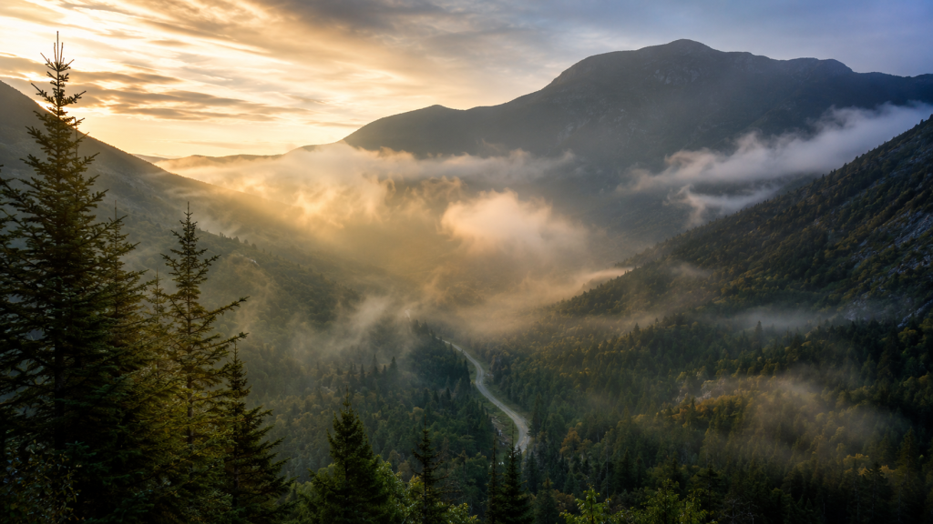
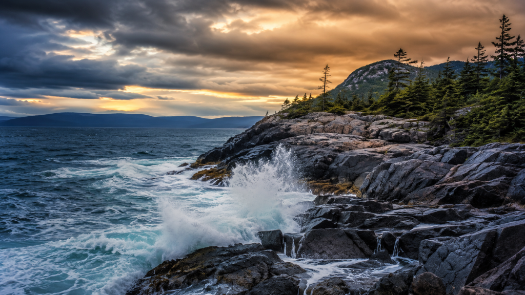
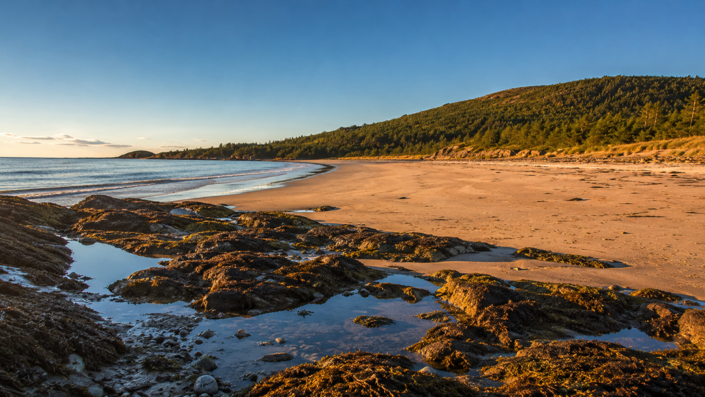
1. Grafton Notch State Park (Newry)
Why it’s special: Grafton Notch is one of Maine’s most dramatic geological features—a deep mountain pass carved by glaciers—but it remains far less crowded than comparable destinations like Franconia Notch in New Hampshire. The park straddles Route 26 and offers multiple approaches to waterfalls, sweeping views, and a trail system that ranges from easy walks to serious alpine challenges.
The experience: Drive Route 26 through the park at a slow pace; the road itself is scenic. Pull over at the various trailheads and short walks, where you can access Screw Auger Falls (a 15-minute detour) or Eyebrow Trail (a moderate 2.7-mile loop with tremendous views). If you’re hiking Old Speck Mountain, go early and expect it to take most of your day—the switchback trail climbs steeply, and near the summit, you’ll cross alpine terrain with incredible 360-degree views. The rock can be slick in wet weather, so bring good boots and patience. The whole area gets quiet by mid-afternoon, and the light changes dramatically in late summer as the sun moves lower.
Getting there:
- Address: 1941 Bear River Road, Newry, ME 04261
- From Portland: Take I-295 north to Route 26 north; approximately 75 miles, 90 minutes
- From Boston: Take I-95 north through New Hampshire, then Route 2 east to Route 26 north; approximately 200 miles, 3.5 hours
- Parking: Large parking area at the park entrance; additional small pulloffs along Route 26 for specific trailheads. Free. The Old Speck trailhead has a dedicated lot.
Practical Info:
- Best season: June through October. September is ideal—fewer bugs, perfect weather, excellent light.
- Hours: Dawn to dusk; no gates
- Entry fee: [VERIFY: current Maine state park day-use fee as of 2026] (historically $5–$7 per vehicle)
- Difficulty levels:
- Eyebrow Trail: Moderate, 2.7-mile loop, 700 ft elevation gain
- Old Speck Mountain: Strenuous, 7.8-mile round trip, 2,700 ft elevation gain; 5–6 hours
- Dog-friendly: Yes, on-leash
- Kid-friendly: Eyebrow Trail is good for older kids; Old Speck is too demanding for most children
- Cell service: Spotty at higher elevations; download offline maps
Where to Stay Nearby:
- Budget: Bethel Village Station Motel, Bethel, ME (~$80–$110/night) — simple, clean, walkable to town; www.bethelmotel.com
- Mid-range: The Jolly Drayman Inn, Bethel (~$140–$180/night) — restored historic inn with good breakfast; www.jollydraymaninn.com
- Unique: Coos Canyon Glamping, Byron, ME (~$150–$250/night) — canvas safari tents with beds, riverside location; www.cooscanyonglamping.com
Official & Useful Links:
- Grafton Notch State Park – Maine.gov
- AllTrails: Old Speck Mountain Trail
- Maine Trail Finder: Grafton Notch System
Insider Tip: The Eyebrow Trail switchbacks are rocky and exposed, but most people do them in one direction only. If you do the full loop, you’ll pass fewer people on the second half. Park on the east side of Route 26 if you want the loop in reverse and the better afternoon light. Also, the Screw Auger Falls pull-off gets busy, but a smaller waterfall walk to Mother Walker Falls (just south) has a quarter of the traffic.
2. Monhegan Island
Why it’s special: Monhegan Island is a working fishing village 10 miles off the coast, unreachable by car, delightfully free of chain anything, and populated by artists, lobstermen, and a few quiet inns. The trails are impeccably maintained, the views are cinematic, and the fact that you have to take a ferry adds a layer of commitment that naturally deters casual tourists.
The experience: The ferry ride itself (about 50 minutes from Port Clyde or 70 minutes from New Harbor) is part of the experience—you’ll see islands, lighthouses, and possibly seals and puffins depending on the season. Once on the island, there are no cars except service vehicles. Trails weave through spruce forests and along rocky cliffs. Burnt Head offers dramatic ocean views. Cathedral Woods is quiet and contemplative. The Artist Studio Tour (June–August) gives you a peek into the working studios of resident painters. The island inn and restaurants are modest, and the pace is deliberately slow. Bring a book you want to read. There’s good reason no one hurries here.
Getting there:
- Ferry operators:
- Monhegan Boat Line (Port Clyde): 880 Port Clyde Road, Port Clyde, ME 04855; (207) 372-8848; www.monheganboat.com — 50-minute crossing
- Hardy Boat Cruises (New Harbor): (207) 677-2026; www.hardyboat.com — 70-minute crossing
- Parking: At both ferry terminals (lot fees $6–$10/day)
- From Portland: Route 1 south to Port Clyde (about 50 miles, 90 minutes) or to New Harbor (45 miles, 75 minutes)
Practical Info:
- Best season: June–September. May and October are quieter but weather is unpredictable. June brings puffins to Matinicus Rock (visible from boat).
- Ferry hours: [VERIFY: current 2026 ferry schedule] Typically 2–3 trips daily depending on season
- Ferry cost: [VERIFY: current passenger fares] (historically $35–$45 round trip for adults)
- Island accommodations are limited and must be booked in advance (see below)
- Trails: Network of 12+ trails; mostly easy to moderate, well-marked
- Dog-friendly: Yes, on-leash on trails
- Kid-friendly: Yes, the ferry is an adventure for children
- Cell service: Decent in town; weaker in forest
Where to Stay Nearby (Island):
- Budget: [VERIFY: current budget options] — Monhegan Island doesn’t have hostels; camping is not permitted
- Mid-range: The Island Inn, Monhegan Island (~$150–$200/night) — historic inn, good restaurant, central location; www.islandinnmonhegan.com
- Unique: Trailing Yew, Monhegan Island (~$120–$180/night) — rustic, artist-friendly guesthouse with shared baths; www.trailingyew.com
Alternative Stay (Mainland, Port Clyde):
- Mid-range: The Seaside Inn, Port Clyde (~$130–$170/night) — small inn with waterfront rooms; www.seasideinnportclyde.com
Official & Useful Links:
Insider Tip: If the ferry is choppy, take the Monhegan Boat Line’s version (the Laura B) from Port Clyde—it’s smaller and cuts the water differently, which some people find smoother. Most visitors take the ferry morning and leave afternoon, so if you spend the night, you get the island almost to yourself at dawn and dusk. The Burnt Head Trail trail at sunrise, before anyone else gets there, is magical.
3. Tumbledown Mountain (Weld)
Why it’s special: Tumbledown Mountain sits in the western lakes region of Maine, far from coastal crowds, and offers genuine alpine scenery—a true summit with 360-degree views, a pristine mountain pond, and the kind of trail that makes hikers feel like they’ve discovered something. It’s consistently ranked among Maine’s best hikes by locals but rarely mentioned in mainstream travel guides.
The experience: The approach is steep and rocky; this isn’t a casual stroll. You’ll climb through a dense forest, cross boulder fields, and scramble up rock to the summit. The payoff is a granite peak with far views across the lake country. The loop descent takes you past Little Jackson’s summit (smaller, quieter) and then down through Parker Ridge. Near the bottom, you’ll pass a pristine mountain pond—it’s cold enough to swim in on a hot day, which is a genuine shock after climbing hard. Bring water and snacks; there are no services for miles. The trail gets muddy in spring and early summer, so go mid-July or later if you can.
Getting there:
- Trailhead parking: Byron, ME (Township 6 North of Weld)
- Address: [VERIFY: exact parking lot address] — GPS: 44.77°N, 70.77°W
- From Portland: Route 2 west to Route 219 north; approximately 80 miles, 2 hours to trailhead
- From Grafton Notch: Route 26 south to Route 2 west; approximately 40 miles, 1 hour
- Parking: Trailhead lot; free, typically 12–15 spaces
Practical Info:
- Best season: Mid-July through September. May–June is too muddy; October is fine but weather gets variable.
- Hours: Open year-round, dawn to dusk
- Entry fee: Free
- Difficulty: Moderate to Strenuous, depending on how much of the loop you do
- Loop as described: 5.6–6.0 miles, 1,800–2,000 ft elevation gain, 4–5 hours
- Dog-friendly: Yes (they’ll love swimming in the pond)
- Kid-friendly: Only for kids 10+, and prepared for a genuine challenge
- Cell service: None at trailhead or summit
Where to Stay Nearby:
- Budget: Kawanhee Inn Camping Area, Weld (~$25–$40/night for tent camping) — rustic, lakefront; www.kawanheecampground.com
- Mid-range: The Kawanhee Inn, Weld (~$130–$170/night) — historic 1881 lodge on the lake, good food; www.kawanheeinn.com
- Unique: Woodland Camps, Weld (~$150–$220/night) — classic Maine cottage rentals, waterfront; www.woodlandcampsweld.com
Official & Useful Links:
Insider Tip: The parking lot can be surprisingly full on weekends in peak season, but most people do the loop in 4–5 hours. If you start by 7 a.m., you’ll have the mountain nearly to yourself for at least the first hour. The brook crossings near the summit can be tricky after heavy rain; if you hear rush above you, wait or turn back. Also, don’t rely on your phone for navigation here—download the AllTrails offline map beforehand.
4. Schoodic Peninsula (Acadia National Park)
Why it’s special: Schoodic Peninsula is the quieter sibling of Mount Desert Island’s Acadia. It receives only about 8% of Acadia’s total visitors, yet it offers dramatic coastal scenery, excellent hiking, and one of the most stunning scenic drives in Maine—all without the crowding or the resort-town vibe of Bar Harbor.
The experience: The Schoodic Loop Road (7 miles) takes you along rocky headlands with views of crashing waves and distant mountains. Pull off at Point, hike Schoodic Head Trail (1.8 miles, moderate), and you’ll stand on a granite peak overlooking open ocean with almost no one else around. The light here changes dramatically with weather and time of day; I went on a foggy afternoon and felt like I was standing at the edge of the world. There are picnic areas, but they’re genuinely quiet. If you time it for a weekday or shoulder season, you might have entire pulloffs to yourself. The park entrance fee feels small compared to the experience.
Getting there:
- Park entrance: Schoodic Peninsula, Winter Harbor, ME
- Address: Schoodic Ranger Station: 245 State Highway 186, Winter Harbor, ME 04693
- From Portland: Route 1A to Route 186 south; approximately 115 miles, 2.5 hours
- From Bar Harbor: Cross to mainland and drive south via Routes 3 and 186; approximately 40 miles, 1 hour
- Parking: Free parking at various pulloffs along Schoodic Loop; dedicated lot at the ranger station
Practical Info:
- Best season: June–September. October is beautiful and quieter.
- Hours: Park open year-round; Schoodic Loop accessible 24/7
- Entry fee: [VERIFY: 2026 Acadia NP entrance fee] (historically $30 per vehicle, valid for 7 days)
- Schoodic Head Trail: Moderate, 1.8 miles round trip, 440 ft elevation gain, 1.5–2 hours
- Dog-friendly: Yes, on-leash on trails
- Kid-friendly: Yes; shorter trails and scenic drives are family-appropriate
- Cell service: Good throughout
Where to Stay Nearby:
- Budget: Bluebird Motel, Winter Harbor (~$80–$110/night) — simple, clean, family-owned; www.bluebirdmotelwinterharbor.com
- Mid-range: Schoodic House, Winter Harbor (~$140–$180/night) — in-town inn with good views; www.schoodichouse.com
- Unique: Acadia Bay Inn, Sullivan Harbor (~$150–$210/night) — small inn with oceanfront location, excellent restaurant; www.acadiabayinn.com
Official & Useful Links:
- Acadia National Park – Schoodic Peninsula
- Schoodic Peninsula Official Website
- AllTrails: Schoodic Head Trail
Insider Tip: If you’re visiting Mount Desert Island and want to escape the crowds, Schoodic is just 45 minutes away. Go mid-week if possible. Also, the Blueberry Hill Trail parking lot, about halfway around the loop, almost never fills; it offers excellent ocean views and is less trafficked than the main scenic pulloffs.
5. Moxie Falls (The Forks)

Why it’s special: Moxie Falls is one of Maine’s highest waterfalls (about 90 feet of a single drop), but it remains far less crowded than famous falls elsewhere in the state. The hike is accessible—just 1.7–2 miles round trip—but far enough off the beaten path that most casual tourists miss it entirely. The waterfall is spectacularly concentrated in a narrow gorge.
The experience: The trail itself is mostly gentle, with a boardwalk and bridges over streams. Then suddenly you emerge at the base of a powerful waterfall plunging from a narrow canyon. The spray is real and cold. The sound is immense. You can feel the power of the water in a way that photos can’t capture. Go in late May or June when snowmelt is still feeding the falls (they’re more dramatic), or in September when the water is still strong but the crowds are gone. The parking area is small and simple; if it’s full, that means only 8–10 cars, which tells you how quiet this place actually is.
Getting there:
- Trailhead: The Forks, Maine (Moxie Gore area)
- Address: [VERIFY: exact parking lot address] — GPS: 45.31°N, 70.11°W
- From Portland: Route 201 north; approximately 90 miles, 2 hours to The Forks, then local directions
- From Greenville/Moosehead Lake: Route 15 south; approximately 30 miles, 1 hour
- Parking: Small dirt lot; free, typically 6–8 spaces
Practical Info:
- Best season: May–September; June is optimal
- Hours: Open year-round, dawn to dusk
- Entry fee: Free
- Difficulty: Easy, 1.7–2.0 miles round trip, minimal elevation gain, 45–60 minutes
- Dog-friendly: Yes
- Kid-friendly: Yes, great for families
- Cell service: Spotty
Where to Stay Nearby:
- Budget: Northern Outdoors Resort Campground, The Forks (~$30–$45/night for tent) — on-site brewery and rafting; www.northernoutdoors.com
- Mid-range: The Forks Resort, The Forks (~$120–$160/night) — on the Kennebec River, good restaurant; www.forksresort.com
- Unique: Coos Canyon Lodge Airbnb options, Byron/Forks area (~$100–$180/night) — rustic cabins, private sites; Airbnb search for “Forks Maine cabins”
Official & Useful Links:
Insider Tip: The trail can be muddy even days after rain, so wear shoes with real grip. The parking lot is accessed from a dirt road that may be rough in spring; a regular sedan is fine, but take it slow. If you’re combining this with a day trip from Greenville (where you might kayak or hike elsewhere), Moxie Falls makes an excellent half-day add-on hike in the morning.
6. Reversing Falls (Pembroke)
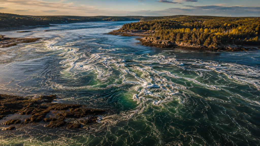
Why it’s special: Reversing Falls is a tidal phenomenon where the enormous tides of the Bay of Fundy region (up to 24 feet) cause a river to literally reverse its flow twice daily. It’s rare, strange, and compelling—a natural process that commands full attention. The Downeast Coastal Conservancy has recently improved trails, making the area more accessible without making it crowded.
The experience: Arrive around the time of slack water (the transition between tides) or low tide, and you’ll see the drama unfold. The river changes direction before your eyes. For an hour or two, water reverses and boils with currents. The trails loop around with viewpoints, and the conservancy has been thoughtful about trail-building—they blend into the landscape rather than dominating it. Bring a tide table or check the Reversing Falls schedule before you go; timing is everything. The surrounding area is rural and quiet; Pembroke is a real working town, not a tourist destination.
Getting there:
- Reversing Falls Park / Downeast Coastal Conservancy: Pembroke, ME
- Address: Reversing Falls Park, Pembroke, ME (park entrance off US Route 1)
- From Lubec: US Route 1 west; approximately 20 miles, 35 minutes
- From Bar Harbor: US Route 1 east; approximately 100 miles, 2.5 hours
- From Portland: US Route 1 northeast to Pembroke; approximately 180 miles, 3.5 hours
- Parking: Free lot at the park entrance
Practical Info:
- Best season: May–September for comfortable hiking; the tidal phenomenon works year-round.
- Hours: Park open dawn to dusk year-round
- Entry fee: Free (donation suggested)
- Trails: Multiple loops, 1–3 miles, easy to moderate, well-marked
- Dog-friendly: Yes
- Kid-friendly: Yes, kids find the reversing water fascinating
- Cell service: Decent in Pembroke
Where to Stay Nearby:
- Budget: Eastland Motel, Eastport (~$75–$110/night) — 20 minutes east, basic clean rooms; www.eastlandmotel.com
- Mid-range: The Riverside Inn, Calais (~$110–$150/night) — 45 minutes west, on the St. Croix River; www.riversideinnmaine.com
- Unique: Peacock House B&B, Eastport (~$100–$150/night) — historic 1850s sea captain’s house; www.peacockhousebb.com
Official & Useful Links:
- Reversing Falls Park – Downeast Coastal Conservancy
- Reversing Falls Tide Times
- Frenchman Bay Conservancy – Tidal Falls Info
Insider Tip: The best time to visit is around new and full moons, when tides are largest (called “spring tides”). Download a tide app before you go and set a reminder for slack water. The trails are less crowded on weekdays and in June/September. Also, Pembroke is only 20 miles west of Eastport, Maine’s easternmost city, so if you combine this with Quoddy Head (see below), you’ve got a genuine “edge of the United States” trip.
7. Quoddy Head State Park (Lubec)
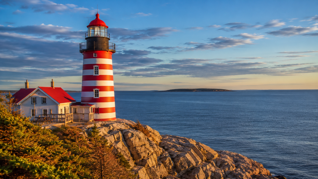
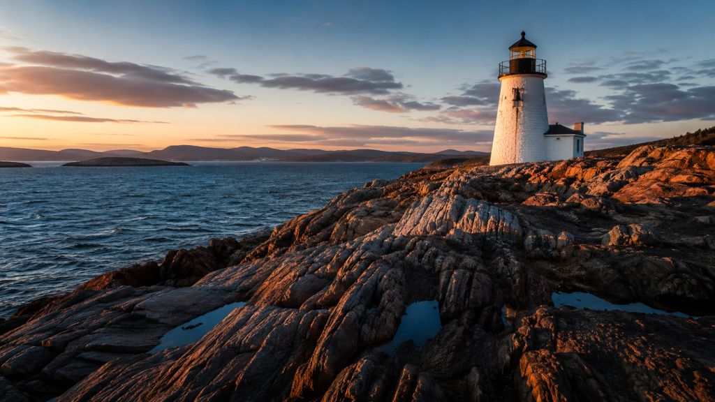
Why it’s special: Quoddy Head is home to West Quoddy Head Lighthouse, Maine’s only candy-striped lighthouse, and it sits at the easternmost point of the continental United States. It’s a genuine “edge of the continent” experience—you can feel it. The lighthouse is iconic, but the trails around it offer quiet coastal walks with views across the Gulf of Maine. It’s far enough from major population centers that it stays peaceful.
The experience: The lighthouse is striking in person—the red-and-white stripes are bold and beautiful. Walk the surrounding trails (the Head Trail loop is about 1.2 miles) and you’ll get wind-carved spruce, tide pools, and views toward Canada. The light changes hour-to-hour on the exposed headland. On clear days, the sight lines are enormous. Fog rolls in and creates an entirely different mood. The museum in the lighthouse keeper’s house has good historical context but is not required. This is one of those places where standing at the edge and looking out is the main event.
Getting there:
- West Quoddy Head State Park: 973 South Lubec Road, Lubec, ME 04652
- From Portland: US Route 1 northeast; approximately 160 miles, 3 hours to Lubec
- From Bar Harbor: US Route 1 northeast; approximately 110 miles, 2.5 hours
- Parking: Free lot at the park entrance; can fill in peak season but usually has space
Practical Info:
- Best season: May–October; June–August is warmest; September–October has excellent light and fewer people
- Park hours: 9 a.m. to sunset daily
- Museum/lighthouse hours: [VERIFY: 2026 lighthouse museum hours] — Typically 10 a.m.–4 p.m., weekdays and weekends vary by season
- Entry fee: [VERIFY: 2026 state park day-use fee] (historically $3–$5 per vehicle); museum entry separate [VERIFY: current price, likely $3–$5]
- Trails: Head Trail (1.2 miles, easy); longer loops available, all easy to moderate
- Dog-friendly: Yes, on-leash
- Kid-friendly: Yes
- Cell service: Decent in Lubec town, spotty at the headland
Where to Stay Nearby:
- Budget: Eastland Motel, Eastport (~$75–$110/night) — 20 minutes west, simple, family-owned; www.eastlandmotel.com
- Mid-range: The Lubec House, Lubec (~$120–$160/night) — in town, waterfront views, good restaurant; www.lubechouse.com
- Unique: Peacock House B&B, Eastport (~$100–$150/night) — historic sea captain’s home, excellent breakfast; www.peacockhousebb.com
Official & Useful Links:
- West Quoddy Head Lighthouse & State Park
- West Quoddy Head Lighthouse Museum
- Maine Tourism: Quoddy Head State Park
Insider Tip: If you arrive early (before 9 a.m., when the park officially opens), the gate is often unmanned and you can walk in. The trails are gorgeous in early morning light before day-visitors arrive. The lighthouse is most photogenic mid-morning when the light hits the stripes directly. Also, Lubec is surrounded by water on three sides, so the microclimate can shift quickly—bring layers even on sunny days.
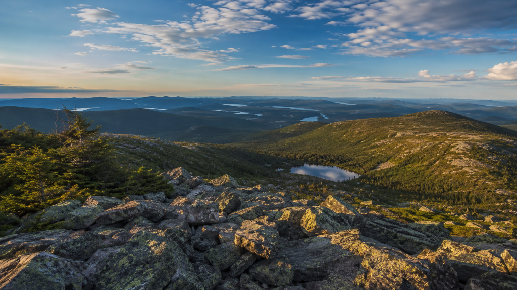
8. Baxter State Park & Mount Katahdin (Millinocket)
Why it’s special: Baxter State Park is a 209,000-acre wilderness in north-central Maine, protected by the will of one man (Percival Baxter) who donated the land to ensure it remained wild. Mount Katahdin, Maine’s highest peak, dominates the park, but the park itself is vast and offers trails for every level. It’s a genuine wilderness experience, accessible yet remote.
The experience: This isn’t a quick stop. Baxter demands time. You can do a day hike (Chimney Pond Trail offers views without summiting Katahdin), or you can go for the full Katahdin climb if you’re experienced and have a reservation. The park roads are unpaved and wind through real forest. You’ll see moose, bears, and landscapes that feel unchanged for a hundred years. The park has strict rules about no RVs over 8 feet tall and no printed signs once you enter—it’s deliberate anti-tourism design. That’s exactly the point. The park lodge and ranger stations are modest. There are no restaurants or facilities inside; you bring supplies or eat what’s available at the gatehouse.
Getting there:
- Baxter State Park Headquarters: 64 Balsam Drive, Millinocket, ME 04462
- From Portland: I-95 north to Route 11 north; approximately 225 miles, 4 hours
- From Greenville/Moosehead Lake: Route 15 north to Route 11; approximately 70 miles, 1.5 hours
- Park entrance: Route 11 northbound, clearly marked
- Parking: Lot fees for day-use: [VERIFY: 2026 fees] (historically $10–$15 per vehicle); Katahdin Trailhead parking requires advance reservation ($10)
Practical Info:
- Best season: June–September for day hiking; October early season becomes very cold at elevation
- Park hours: [VERIFY: 2026 opening/closing schedule] — Typically opens mid-May for day-use; Katahdin summit access varies by weather and snow
- Camping: Available if reserved in advance; must reserve through the park’s system
- Day-use entry: No reservations required for general park exploration; required only for Katahdin-specific trailheads
- Difficulty varies greatly:
- Chimney Pond Trail: Moderate, 3.2 miles round trip, 900 ft gain, 2–3 hours
- Mount Katahdin (Baxter Peak): Strenuous, 10–14 miles depending on route, 4,170 ft elevation gain, 8–10 hours
- Dog-friendly: No; strictly prohibited
- Kid-friendly: Day hikes yes; Katahdin no (too extreme)
- Cell service: None; bring offline maps and a compass
Where to Stay Nearby:
- Budget: Moosehead Campground, Greenville (~$30–$45/night) — well-maintained, lakefront; www.mooseheadcampground.com
- Mid-range: The Birches Resort, Rockwood (~$120–$160/night) — on Moosehead Lake, full resort with restaurant; www.birches.com
- Unique: Indian Hill Trading Post Cabins, Greenville (~$80–$130/night) — simple rustic cabins, authentic; www.indianhilltradingpost.com
Official & Useful Links:
- Baxter State Park Official Website
- Baxter State Park Camping Reservations
- Maine Trail Finder: Baxter Trails
Insider Tip: If you want Baxter without committing to a full Katahdin attempt, do Chimney Pond Trail instead. It offers stunning views into the cirque basin without the scrambling and commitment of the summit. Also, bring bug spray even in September; the blackflies and mosquitoes are relentless. And if you’re doing a multi-day wilderness trip, the park has true backcountry shelters and lean-tos that feel like stepping back in time. Book those far in advance.
9. Morse Mountain to Seawall Beach (Phippsburg)
Why it’s special: Morse Mountain offers coastal views and a genuine beach hike without the fanfare of more famous Maine coastal trails. The mountain itself is modest in elevation (820 feet) but offers excellent views, and the trail ends at a long, quiet sandy beach. It’s accessible to most fitness levels, family-friendly, and yet rarely crowded because it lacks the name recognition of Acadia trails.
The experience: The trail climbs steadily through a beautiful mixed forest—some sun, mostly shade. The path is well-maintained and clearly marked. As you approach the summit, the forest opens and views begin. From the top, you see Casco Bay, islands in the distance, and the Androscoggin River estuary. The descent is a different route, and eventually you emerge onto Seawall Beach—a long expanse of sand and rocks where you can walk for half a mile in either direction with few people. Bring water and snacks; there’s nothing once you leave the trailhead. Go on a sunny day if you want beach time at the end.
Getting there:
- Trailhead: Bates-Morse Mountain Conservation Area, Phippsburg, ME
- Address: Parking lot on Morse Mountain Road, Phippsburg, ME (off Route 209)
- From Portland: Route 209 south toward Phippsburg (via Bath); approximately 30 miles, 50 minutes
- From Brunswick (Bowdoin College area): Route 209 south; approximately 15 miles, 30 minutes
- Parking: Free lot, usually has space (up to 40 cars), but fills on sunny summer weekends
Practical Info:
- Best season: May–October; June–September is warmest; September has excellent light and fewer crowds
- Hours: Open dawn to dusk year-round
- Entry fee: Free (suggested donation $3–$5)
- Difficulty: Easy to Moderate, 2.2–2.6 miles round trip (depending on beach walk), 400–500 ft elevation gain, 1.5–2.5 hours
- Dog-friendly: No (dogs prohibited by conservancy rules)
- Kid-friendly: Yes, good for families
- Cell service: Good signal in the area
Where to Stay Nearby:
- Budget: Mid-Coast Motel, Brunswick (~$85–$120/night) — basic, clean, family-owned; www.midcoastmotel.com
- Mid-range: The Merrymeeting Inn, Brunswick (~$130–$180/night) — restored historic inn, good breakfast; www.merrymeeting.com
- Unique: Salt & Sage Farmstays, various locations near Bath (~$100–$160/night) — farm accommodations with farm-to-table meals; www.saltandsagefarmstays.com
Official & Useful Links:
- Bates-Morse Mountain Conservation Area
- AllTrails: Morse Mountain to Seawall Beach
- Phippsburg Chamber of Commerce
Insider Tip: Check the lot availability website (www.BMMparking.com) before heading out on weekends; it shows real-time parking status. If the lot is full, don’t wait around—it usually doesn’t free up. Go on a cloudy weekday morning if possible. The trail can be muddy or icy depending on season, so wear boots with grip. Also, the beach is cold for swimming even in summer, but wading is refreshing after the hike.
10. Gulf Hagas (Brownville)
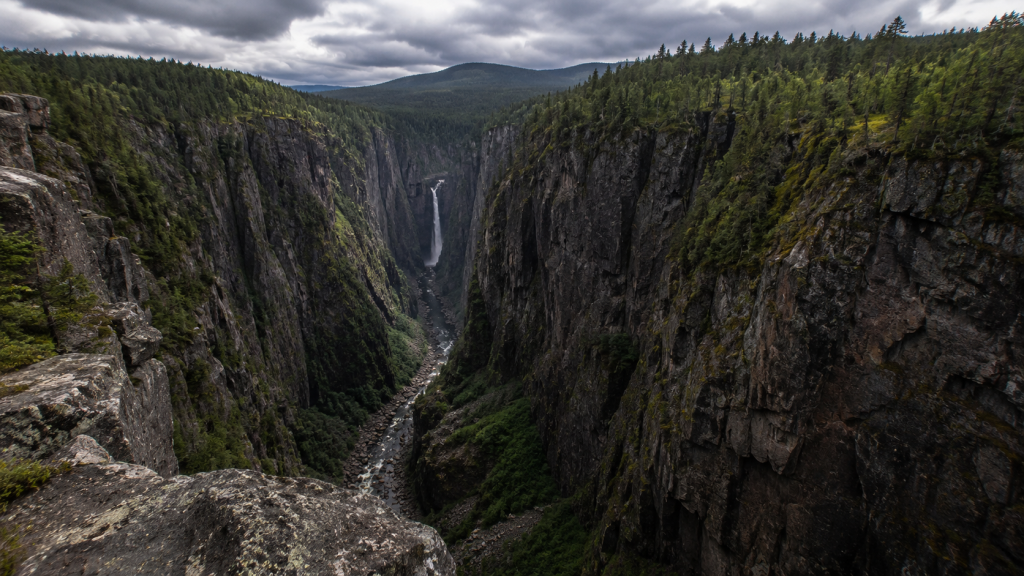
Why it’s special: Gulf Hagas is a deep gorge carved by the Pleasant River in the remote interior of Maine. It’s called “The Grand Canyon of Maine” for good reason. The rim trail offers dramatic waterfalls, overlooks, and a genuine wilderness experience. Unlike Baxter or Moosehead, Gulf Hagas is on private land managed by a timber company, which has kept it quiet and wild-feeling. The 40+ miles of rough road to get there naturally limits visitors.
The experience: This is a genuine backcountry experience. The road to the trailhead is long, rough, and takes you through active forest where you’ll see logging trucks (they have priority, you step aside). Once you’re at the Gulf, the trail hugs the rim of a deep gorge with sheer drops and multiple waterfalls. The river is far below, roaring. The isolation is real—you’re hours from any town, with no cell service and no safety net. The Rim Trail can be done as a loop (8.5 miles, moderate to strenuous). Slot Canyon is a technical scramble with serious exposure if you’re not comfortable with heights. Most people do the Rim Trail and skip the canyon. Go in dry conditions; the rocks are slick and dangerous when wet.
Getting there:
- Trailhead: Gulf Hagas Rim Trail, off KI Road near Brownville, ME
- Address: [VERIFY: exact KI Jo-Mary Road address and directions] — The road is rough; high-clearance vehicle recommended
- From Brownville: KI Road north, approximately 40 miles, 1.5–2 hours of slow driving on rough road
- From Greenville/Moosehead: Route 6/15 south to KI Road; approximately 50 miles, 2–2.5 hours
- From Portland: Route 11 north to Brownville, then KI Road; approximately 220 miles, 4.5 hours
- Parking: Small lot at the trailhead; free, usually has space (the remoteness naturally limits crowds)
Practical Info:
- Best season: July–September; June can be muddy; October starts getting cold
- Hours: Accessible year-round but road can be impassable in winter; check conditions before going
- Entry fee: Free (Katahdin Iron Works gate fee if entering via private land: [VERIFY: 2026 fee])
- Difficulty:
- Rim Trail loop: Moderate to Strenuous, 8.5 miles, 800–1000 ft elevation gain, 4–6 hours
- Slot Canyon scramble: Strenuous, technical, exposure—requires rock scrambling experience
- Dog-friendly: Yes
- Kid-friendly: Only for kids 10+, and very experienced hikers
- Cell service: None
Where to Stay Nearby:
- Budget: Lily Bay State Park Campground, Greenville (~$25–$40/night for tent) — lakefront, well-maintained; www.maine.gov/dacf/parks
- Mid-range: The Birches Resort, Rockwood (~$120–$160/night) — on Moosehead Lake, full amenities; www.birches.com
- Unique: Indian Hill Trading Post Cabins, Greenville (~$80–$130/night) — rustic, authentic, community feel; www.indianhilltradingpost.com
Official & Useful Links:
- Maine Trail Finder: Gulf Hagas
- AllTrails: Gulf Hagas Rim Trail
- KI Jo-Mary Forest Management Information
- Greenville/Moosehead Lake Chamber
Insider Tip: This is not a spontaneous trip. Plan ahead, check road conditions, and bring supplies—the last resupply point is Brownville, which is 40+ miles away. A high-clearance vehicle (not necessarily 4WD, but good ground clearance) is essential. The parking lot is never crowded, but that’s because the remoteness self-selects for serious hikers. The gorge is genuinely stunning, and the solitude is part of what makes it special. Go on a clear day; fog in the gorge is atmospheric but compromises safety.
Planning Your Trip — Getting Around
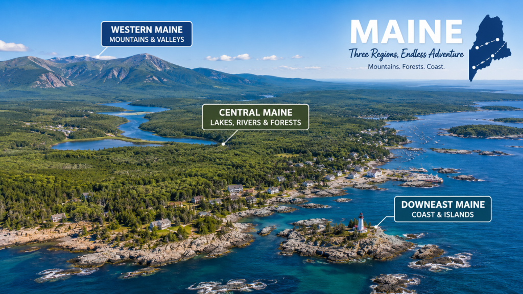
Maine’s geography sprawls across a large area, and your route depends on which hidden gems you want to visit. If you’re hitting coastal and mid-coastal locations (Monhegan, Quoddy Head, Schoodic, Reversing Falls), plan on distances of 80–180 miles between stops. Interior destinations (Grafton Notch, Baxter, Gulf Hagas, Tumbledown) cluster better but require longer drives from the coast.
Nearest major airports: Portland International Jetport (PWM, 6 miles from Portland, ME) is the closest for most of Maine. Boston Logan (BOS, about 2 hours south) offers more flight options if prices are better. Bangor International (BGR, 2 hours north of Portland) serves eastern and northern Maine. Plan to rent a car—public transportation within Maine is minimal.
Best time of year: September is the single best month for this itinerary. Late August is also excellent. Why? The summer tourist season has peaked and is fading, but the weather is still warm and reliable. The nights cool enough to sleep well in a tent or car. Hiking conditions are ideal—trails are dry, bugs are diminishing. September also brings early color to certain elevations, creating dramatic light. October is beautiful but weather becomes variable and unpredictable. Summer (July–early August) is busy and buggy. June can be muddy. Winter is spectacular but demands experience; spring is muddy, cold, and unpredictable.
Road conditions: Maine’s main roads (I-95, US Route 1) are well-maintained year-round. Secondary roads and forest roads vary. Grafton Notch’s Route 26 is fine in summer/fall. The KI Road to Gulf Hagas requires high-clearance vehicle and can be impassable in winter. All park roads are unplowed in winter. If you’re going September or later, confirm that interior park roads are still open; some close as weather turns.
4WD/High-clearance requirement: A standard sedan is fine for Schoodic, Quoddy Head, Monhegan ferry approaches, Tumbledown, Moxie Falls, Reversing Falls, and Morse Mountain. High-clearance (non-4WD) helps at Grafton Notch. For Baxter State Park, standard sedan is fine on main roads. For Gulf Hagas KI Road, high-clearance is essential; 4WD is useful but not always necessary.
Cell service and offline maps: Cell service is good in towns (Portland, Greenville, Bar Harbor) and poor to absent in remote areas. Download Google Maps offline maps before you go. AllTrails premium membership includes offline trail maps, which is worth the investment if you’re doing multiple hikes. For Gulf Hagas and Baxter interior, assume no service.
Sample itineraries:
One-day from Portland: Morse Mountain + Seawall Beach (easy, 1.5 hours each way).
Three-day weekend: Day 1: Grafton Notch and Eyebrow Trail + stay in Bethel. Day 2: Tumbledown Mountain. Day 3: Return to Portland via scenic Route 2.
Five-day deep trip: Day 1: Monhegan Island overnight. Day 2: Schoodic Peninsula. Day 3: Quoddy Head and Reversing Falls. Day 4: Drive inland to Greenville, scout Moosehead. Day 5: Moxie Falls or early morning Baxter hike, return to Portland.
Full week interior/wilderness: Day 1: Grafton Notch. Days 2–3: Baxter State Park (Chimney Pond Trail + exploration). Days 4–5: Greenville base, Moosehead exploration. Day 6: Gulf Hagas (full day). Day 7: Return to Portland.
Where to Eat Along the Way
The Good Food Store, Bethel, ME — Farm-to-table casual dining. Excellent soups, sandwiches on good bread, local pastries. Known locally for real ingredients and no corporate feel. $8–$16 per entree. www.thegoodfoodstore.com
Cold River Vodka Distillery Restaurant, Fryeburg, ME (on the way to Grafton Notch) — Distillery with restaurant attached. Fresh food, creative cocktails, scenic riverside seating. Excellent burger. $14–$24 per entree. www.coldrivervodka.com
The Wandering Goose, Greenville, ME — Casual restaurant and brewery focused on local Maine ingredients. Great breakfast, solid lunch/dinner. Moose burgers when available. $10–$20 per entree. www.wanderinggoosemaine.com
If you enjoyed this guide, check out our article on Hidden Gems Across New England or our guide to Underrated National Parks Near New England
Final Thoughts
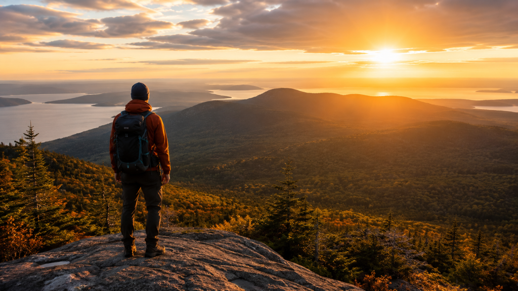
Maine’s hidden corners aren’t hidden because they lack beauty or access—they’re overlooked because they don’t have the infrastructure of the tourism machine. No gift shops, no crowds, no Instagram-optimized overlooks. That’s the whole point. The places in this guide deliver something genuine: real forest, real waterfalls, real solitude, and real views. They ask something of you—a drive on a rough road, a reservation, a small entry fee, willingness to hike—but they reward that effort with experiences that stick with you.
I came to Maine expecting the coast and lighthouses. I found those, yes, but I also found deep gorges with no other people, summits with views I’ll remember for years, and the kind of quiet that makes you remember what silence actually sounds like. That’s what Maine offers if you’re willing to drive past the obvious.
If you’ve been to any of these places, I’d love to hear about it. Drop a comment below and tell me what surprised you, what you found that I didn’t, or what I got wrong about a location. The best hidden gems are the ones that locals keep updating.
Maine isn’t finished surprising you. You just have to turn down the right road.
Frequently Asked Questions
Q: When is the best time to visit these hidden gems in Maine?
A: September is ideal—warm days, cool nights, fewer tourists, bugs diminishing, and excellent light. Late August is also great. October is beautiful but weather becomes unpredictable. Summer is crowded and buggy. Spring and early summer can be muddy.
Q: Do I need a 4WD vehicle to visit all 10 locations?
A: No. Most destinations (Monhegan, Schoodic, Quoddy Head, Moxie Falls, Reversing Falls, Tumbledown, Morse Mountain) require only a regular sedan. High-clearance helps at Grafton Notch and is essential for Gulf Hagas KI Road. Baxter works fine with a sedan on main park roads.
Q: Are these trails dog-friendly?
A: Most are; dogs are allowed on-leash at Grafton Notch, Tumbledown, Schoodic, Moxie Falls, Quoddy Head, and Gulf Hagas. Dogs are NOT allowed at Baxter State Park or on Monhegan Island.
Q: How much hiking experience do I need?
A: It varies. Moxie Falls, Reversing Falls, Quoddy Head, and Morse Mountain are easy and suitable for families. Tumbledown, Grafton Notch (Eyebrow Trail), and Schoodic Head are moderate. Old Speck, Gulf Hagas, and Baxter Katahdin climbs require significant experience and fitness.
Q: What should I download/bring for navigation?
A: Download Google Maps offline, AllTrails app (premium for offline maps), and consider a detailed physical trail map for remote areas like Gulf Hagas and Baxter. Assume no cell service in wilderness areas. Bring a compass if you’re experienced with it.