The first thing I heard was water hitting rock somewhere below the tree line, long before I saw it. I’d pulled off a gravel forest road in Tucker County with no real plan except to follow the sound, and ten minutes later I was standing knee-deep in a cold pool with a 35-foot curtain of water pounding the back of my neck and not another soul in sight. No ticket booth. No crowd jockeying for the same photo spot. Just the river doing what it’s done for ten thousand years.
That’s the West Virginia most people drive past on their way to Blackwater Falls or the New River Gorge Bridge, snap the obligatory photo, and leave. This guide covers seven hidden waterfalls in West Virginia that reward the people willing to read a trail map, drive a gravel road, or walk a quarter mile past where everyone else turns around — plus exactly how to find each one, where to sleep nearby, and what to eat on the way.
Table of Contents
Why West Virginia Deserves More Attention
West Virginia gets boxed in as a flyover state, somewhere you pass through between Virginia and Ohio. That’s the traveler’s gain, honestly, because it means the back roads stay quiet even in October when the leaves are doing their thing and every other Appalachian state is gridlocked with tour buses.
Here’s what most people don’t know: West Virginia is the only state entirely contained within the Appalachian Mountains, and it’s also the third-most-forested state in the country, behind only Maine and New Hampshire. That forest cover is exactly why there are waterfalls tucked into hollows that don’t show up on the official tourism maps — the terrain is so folded and creased that streams drop suddenly and often, and a lot of those drops never got a parking lot built next to them. Sandstone Falls, down in the New River Gorge, is also one of the widest waterfalls east of the Mississippi at roughly 1,500 feet across — and most travelers have still never heard of it.
This guide for hidden waterfalls in West Virginia skips that one in favor of seven that are smaller, quieter, and in most cases require you to actually go looking. That’s the whole point.
7 Hidden Waterfalls in West Virginia Worth the Drive
1. Mill Creek Falls (Kumbrabow State Forest)
Why it’s special: Mill Creek Falls sits inside Kumbrabow State Forest, the highest state forest in West Virginia at elevations between 3,000 and 3,930 feet, and the forest itself sees so little traffic that you’ll likely have the 20-foot falls entirely to yourself. The water drops into a deep, clear swimming hole ringed by rhododendron, and the whole place has the hush of somewhere genuinely remote rather than just “off the main road.”
The experience: You walk down a set of wooden steps from the parking area and the temperature drops a few degrees as soon as you’re in the gorge — that’s the rhododendron canopy doing its job. Midday in summer is your window for swimming since the pool gets full sun for a few hours; visit at dawn for photography and you’ll likely catch mist rising off the water. Brook trout dart through the shallows if you stand still long enough to notice them.
Getting there:
- GPS: approximately 38.733, -80.118 (forest entrance off Rt 219-16)
- From Elkins, WV: take US-219 South for about 24 miles to Elkwater, turn onto Rt 219-16 (Kumbrabow Forest Road), and follow it roughly 3.5 miles to a three-way intersection. Continue straight/right about 1.4 miles on gravel to a small parking area just before the creek crossing.
- From Huttonsville, WV: it’s about 7 miles south via the same forest road.
- Drive time: roughly 40 minutes from Elkins, 20 minutes from Huttonsville
- Parking: free gravel pullout, fits 6–8 cars, unpaved
Practical Info:
- Best season: May through October; the access road can be rough or snow-covered in winter
- Hours: forest grounds open year-round, day use is unrestricted
- Entry fee: none
- Difficulty: easy, less than 0.2 miles on wooden steps to the falls
- Dog-friendly: yes, on leash | Kid-friendly: yes, but supervise near the pool edge
- Cell service: none — there is essentially no signal anywhere in Kumbrabow State Forest
Where to Stay Nearby:
- Budget: Kumbrabow State Forest Campground (13 primitive sites, no hookups), [VERIFY: current nightly rate as of 2026] — wvstateparks.com
- Mid-range: Elkins Days Inn, Elkins, WV, around $90–120/night — wyndhamhotels.com
- Unique stay: Kumbrabow’s CCC-built rustic cabins (no electricity, wood fireplace, gas appliances), [VERIFY: current nightly rate] — wvstateparks.com
Official & Useful Links:
- Kumbrabow State Forest: wvstateparks.com/park/kumbrabow-state-forest
Insider Tip: Don’t park at the campground entrance — continue past it on the gravel road to the smaller pullout right before the creek crossing. It’s unmarked but it’s the actual trailhead, and it saves you a 10-minute walk back up the road that most visitors end up doing by accident.
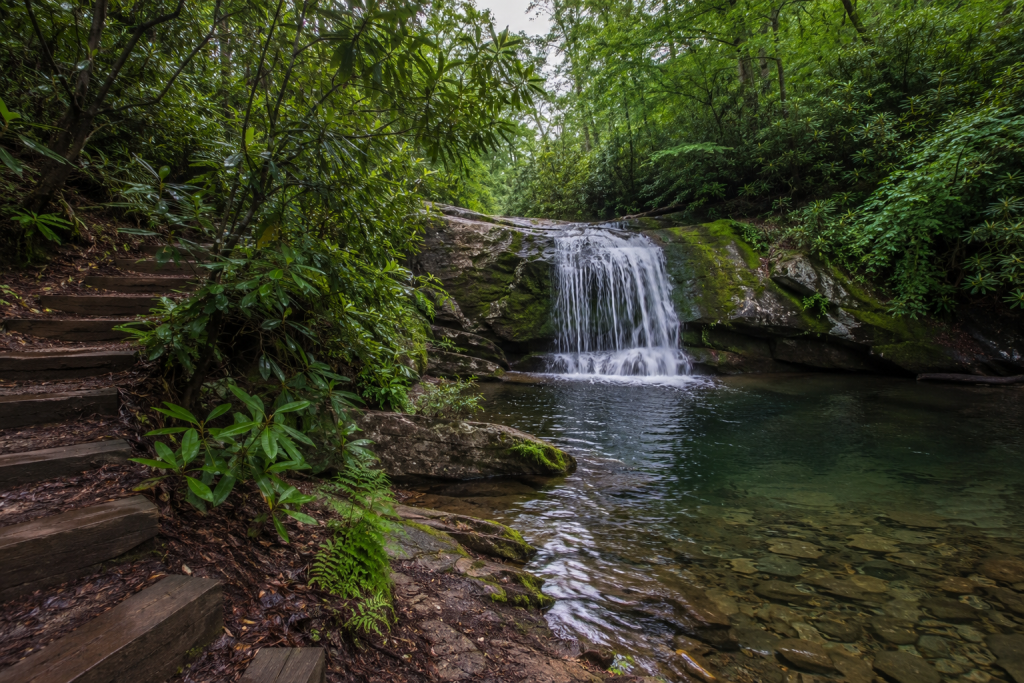
2. Douglas Falls (Thomas)
Why it’s special: Douglas Falls spans the full width of the North Fork Blackwater River at about 35 feet tall, and unlike its famous neighbor Blackwater Falls a few miles away, you’ll likely share it with maybe one other car. The amber-tinted water — stained by tannins from hemlock and red spruce upstream — pours over a wide rock ledge with multiple viewing angles, including a spot where you can stand almost directly behind the curtain.
The experience: The walk in follows an old rail grade along the river, flat and easy, with the sound of the water building well before you see it. Afternoon light works best for photos since the falls face roughly east. Swimming is permitted and genuinely good in summer — just test depth before jumping off any rocks, since water levels shift after rain.
Getting there:
- GPS: approximately 39.124, -79.520
- From Thomas, WV: head south on Route 32 about a mile past downtown (just past The Purple Fiddle), turn onto Douglas Road. Drive roughly 1 mile to where the road meets the old rail trail, then continue or park and walk about a mile down the gravel grade to the falls.
- From Davis, WV: about 10 minutes
- From Morgantown, WV: about 1 hour 15 minutes
- Parking: free gravel lot at the rail trail junction, fits roughly 10 cars; a high-clearance vehicle helps if you plan to drive the final stretch, which has deep potholes
Practical Info:
- Best season: late spring through fall; the river runs highest in April and May
- Hours: no gate, accessible dawn to dusk
- Entry fee: none
- Difficulty: easy, flat 1-mile walk one-way if you don’t drive in
- Dog-friendly: yes | Kid-friendly: yes, on the flat trail; supervise at the falls itself
- Cell service: spotty to none past Thomas
Where to Stay Nearby:
- Budget: Billy Motel & Pub, Thomas, WV, around $90–130/night — billymotelandpub.com
- Mid-range: The Cabins at Blackwater Falls State Park, around $150–220/night — wvstateparks.com
- Unique stay: Tucker House Inn, Davis, WV (historic B&B), — tuckerhouseinn.com
Official & Useful Links:
Insider Tip: Skip driving the access road even if your vehicle can handle it — park at the rail trail junction and walk. You’ll move slower than the trucks rattling past, but you’ll actually hear the river the whole way in instead of your own engine, and there’s a side path about two-thirds of the way down that climbers use to reach a quiet upper pool most visitors never find.
3. High Falls of the Cheat (Glady)
Why it’s special: This is the one for travelers who want to earn their waterfall. High Falls is a horseshoe-shaped cascade over 100 feet wide but only about 20 feet tall, on the remote Shavers Fork of the Cheat River, and the only ways in are a roughly 7-mile round-trip hike or a seasonal scenic train. That logistics barrier is exactly why it stays empty.
The experience: The trail climbs Shavers Mountain through old-growth forest before dropping down to the railroad grade that parallels the river — you’ll walk along live tracks for the final stretch, so stay alert. The falls themselves are wide and loud, more like a long rapid than a single drop, with a deep swimming pool below that’s worth the effort on a hot day. Go in late spring after snowmelt for maximum flow.
Getting there:
- GPS: approximately 38.772, -79.778 (falls); trailhead at 38.749, -79.753
- From Elkins, WV: take US-33 East to Job, then follow Forest Road 44 South about 4 miles past Glady to the High Falls Trailhead.
- Drive time: about 1 hour from Elkins
- Parking: small gravel trailhead lot off Forest Road 44, fits roughly 8–10 cars
Practical Info:
- Best season: April through October for the hike; check seasonal train schedule separately
- Hours: trail open year-round, weather permitting
- Entry fee: none for the hike (train excursion has a separate ticket — [VERIFY: New Tygart Flyer current pricing])
- Difficulty: moderate to strenuous, 7.6 miles round-trip, roughly 1,350 feet of elevation gain
- Dog-friendly: yes, leashed | Kid-friendly: only for experienced young hikers — it’s a long day
- Cell service: none for the entire hike
Where to Stay Nearby:
- Budget: Day Hotel & Suites, Elkins, around $85–110/night — booking.com
- Mid-range: Stonewall Resort, Roanoke, WV, around $160–220/night
- Unique stay: Whittaker’s Western Cabin near Glady (rustic riverside rental),
Official & Useful Links:
Insider Tip: Listen for trains, but don’t assume silence means safety — sound doesn’t travel well around the river bend just before the falls. The locals’ trick is to watch for fresh tie grease or oil sheen on the rails, a sign a train passed recently and another might follow on schedule.
4. Whitaker Falls (Monterville)
Why it’s special: Whitaker Falls is the rare hidden waterfall in West Virginia you can see without hiking a step — it sits right alongside Valley Fork Road on the upper Elk River — but almost nobody stops because there’s no sign and no official pull-off marking it. The series of low cascades drops through smooth bedrock into a long, swimmable pool that locals have used for generations.
The experience: You’ll catch sight of it through the windshield before you consciously register what it is — a flash of white water below the road grade. Pull over carefully (the shoulder is narrow gravel) and walk down a short embankment. Midsummer afternoons bring the best swimming temperatures; the surrounding hemlock keeps the water shaded and cool even when the air is hot.
Getting there:
- GPS: approximately 38.524, -80.195
- From Elkins, WV: take US-219/250/WV-55 South through Beverly and Huttonsville. Near Valley Head, turn onto WV-15, go about 3.9 miles past a large quarry on your left, then turn onto Valley Fork Road (CR 49). Continue roughly 6.7 miles — the falls become visible on your right.
- Drive time: about 50 minutes from Elkins
- Parking: no formal lot; pull onto the gravel shoulder, room for 3–4 cars max
Practical Info:
- Best season: June through September for swimming; visible year-round from the road
- Hours: no restrictions
- Entry fee: none
- Difficulty: easy, no real trail required
- Dog-friendly: yes | Kid-friendly: yes, with supervision near the water
- Cell service: none past Valley Head
Where to Stay Nearby:
- Budget: Elk River Lodge, Monterville, around $70–100/night
- Mid-range: Snowshoe Mountain Resort lodging (seasonal), around $150–250/night — snowshoemtn.com
- Unique stay: Elk Springs Resort cabins, Monterville,
Insider Tip: The quarry mentioned in the directions is your countdown marker — once you pass it, slow down immediately, because the falls appear faster than expected around the next bend and the pull-off is easy to miss doing highway speed.
5. Cathedral Falls (Gauley Bridge)
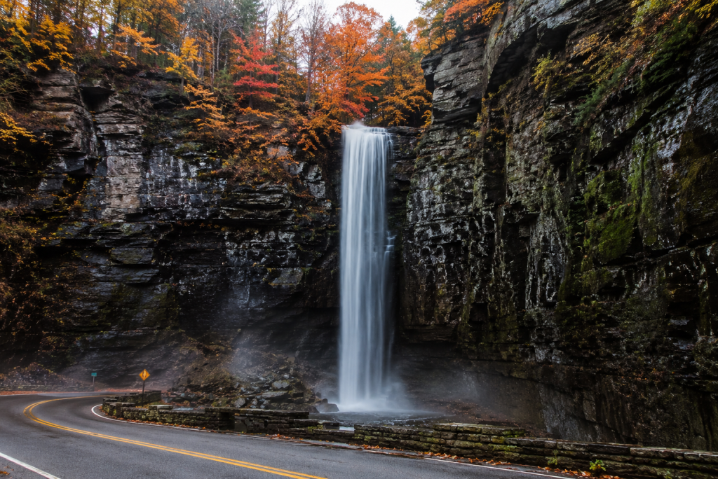
Why it’s special: At over 60 feet, Cathedral Falls is one of the tallest roadside waterfalls in the New River Gorge region, dropping through a narrow sandstone canyon directly beside US Route 60. It’s not unknown exactly, but it’s wildly underrated for how easy it is to reach, and on a weekday morning you’ll often have the small roadside park to yourself.
The experience: The falls are visible from your car the moment you round the bend on Route 60, but the short rock-hop path to the base changes the experience completely — the canyon walls amplify the sound and the spray reaches you well before you reach the pool. Visit after rain for the most dramatic flow; in dry summer stretches it can thin out to what locals jokingly call “Cathedral Trickles.”
Getting there:
- Address/area: US Route 60, about 1 mile east of Gauley Bridge, WV
- GPS: approximately 38.168, -81.180
- From Charleston, WV: take US-60 East through Gauley Bridge; the falls and parking lot appear on the right about 1 mile past town.
- From Fayetteville, WV: take Route 16 North to Gauley Bridge, then continue on Route 60 East for about 2 miles.
- Drive time: about 50 minutes from Charleston, 25 minutes from Fayetteville
- Parking: small paved/gravel roadside lot, fits roughly a dozen cars, fills up on weekends
Practical Info:
- Best season: year-round; frozen in winter is a local favorite, spring after rain is most dramatic
- Hours: open dawn to dusk, day-use park
- Entry fee: none
- Difficulty: easy, a few hundred feet of rock-hopping from the lot
- Dog-friendly: yes | Kid-friendly: yes, but rocks near the base get slippery
- Cell service: generally reliable along Route 60
Where to Stay Nearby:
- Budget: Microtel Inn & Suites, Fayetteville, around $100–130/night
- Mid-range: Hawks Nest State Park Lodge, Ansted, around $130–170/night
- Unique stay: Adventures on the Gorge cabins, Lansing,
Official & Useful Links:
Insider Tip: Go right at opening light, before 8 a.m. The lot is small enough that it backs up by mid-morning in fall foliage season, and the early light angles directly into the canyon for a far better photo than the flat midday glare most visitors get stuck with.
6. Butcher Branch Falls (New River Gorge National Park)
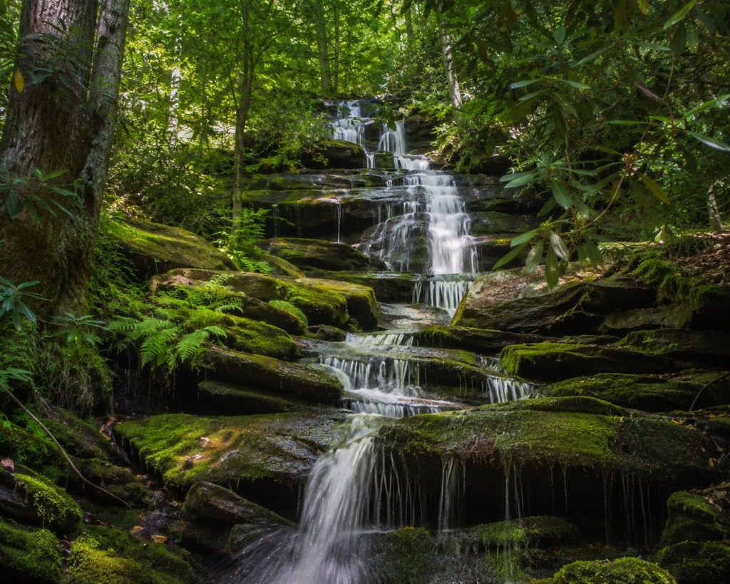
Why it’s special: Less than a mile from a National Park Service trailhead, Butcher Branch Falls still barely registers in guidebooks or park literature, which keeps it genuinely quiet even with the New River Gorge Bridge crowds just a few miles away. The falls drop in tiers down sandstone, fed by a small creek that’s rainfall-dependent — meaning it can disappear in a dry spell and roar back after a storm.
The experience: The trail runs along the cliff rim before switchbacking down into a notch cut by the creek, with a steep, sometimes slick climbing-access spur leading the final stretch to the falls. It’s a proper little adventure — good shoes matter here — and the payoff is a tiered cascade with almost no one else around, even on a busy park weekend.
Getting there:
- Trailhead: Kaymoor Top Trailhead, Kaymoor Road, Fayetteville, WV
- GPS: approximately 38.0625, -81.0726 (trailhead)
- From Fayetteville, WV: take WV-16 South, turn left on Gatewood Road, follow it 2.0 miles, then turn left at the Kaymoor sign (Kaymoor No. 1 Road). Continue about 1 mile to the T intersection, turn left; parking is 50 yards on the right.
- Drive time: about 10 minutes from Fayetteville, 20 minutes from the New River Gorge Bridge
- Parking: NPS gravel lot, fits roughly 15–20 cars
Practical Info:
- Best season: spring and after rain for water flow; fall for foliage
- Hours: park grounds open year-round, day use
- Entry fee: none (New River Gorge National Park has no general entry fee)
- Difficulty: moderate, about 0.9 miles round-trip with a steep, rocky climbing-access spur near the end
- Dog-friendly: yes, leashed | Kid-friendly: only for capable hikers — the final approach is steep
- Cell service: unreliable in the gorge
Where to Stay Nearby:
- Budget: Bridge Haven Cabins & Camping, Lansing, around $40–70/night campsites — bridgehavenwv.com
- Mid-range: Country Road Cabins, Fayetteville, around $120–160/night
- Unique stay: Adventures on the Gorge treehouse/cabin rentals, Lansing,
Insider Tip: Watch for the small wooden “Climbing Access” sign about 0.3 miles in — that unmarked spur, not the main trail continuation, is what gets you down to the falls. Missing it means a much longer detour toward Long Point before you realize your mistake.
7. Dunloup Creek Falls (Thurmond)
Why it’s special: This 20-foot waterfall sits so close to the road into the ghost town of Thurmond that drivers genuinely can’t avoid seeing it — yet most don’t stop, because Thurmond itself (a near-abandoned former coal boomtown) pulls all the attention. That makes Dunloup Creek one of the easiest hidden waterfalls in West Virginia to combine with a genuinely strange, fascinating side trip.
The experience: The falls spill over a wide rock shelf right beside the road, with easy access down to creek level where you can wade in and let the cold mountain water run over your feet. Pair it with a walk through Thurmond’s empty storefronts and the old C&O Railway depot for one of the odder, more memorable stops on this whole trip.
Getting there:
- GPS: approximately 37.938, -81.098
- From Fayetteville, WV: take WV-16 South, then follow signs onto Thurmond Road toward Thurmond. The falls are visible from the road a couple of miles before you reach town.
- From Beckley, WV: about 35 minutes via WV-61 and Thurmond Road
- Drive time: about 20 minutes from Fayetteville
- Parking: small gravel pull-off near the falls, fits 4–5 cars
Practical Info:
- Best season: spring for water volume; year-round access
- Hours: open, no gate
- Entry fee: none
- Difficulty: easy, roadside access
- Dog-friendly: yes | Kid-friendly: yes
- Cell service: very limited near Thurmond
Where to Stay Nearby:
- Budget: Glade Creek Campground, Prince, WV, around $25–35/night
- Mid-range: Resort at Glade Springs, Daniels, WV, around $140–190/night
- Unique stay: Historic Thurmond Depot-area cabin rentals,
Insider Tip: Time your stop for late afternoon, when the train depot building (still standing, still gorgeous in a faded way) catches direct light — and you can usually hear a coal train rumble through the gorge below, which somehow makes the whole abandoned-town atmosphere even better.
Planning Your Trip — Getting Around
The nearest major airports are Yeager Airport (CRW) in Charleston, about 25–80 miles from these falls depending on which cluster you’re chasing, and North Central WV Airport (CKB) near Bridgeport, roughly 30–60 miles from the Elkins/Randolph County falls. Pittsburgh International (PIT) is a larger hub option, about 2.5–3 hours from Thomas and the northern falls.
The best overall window is late September through mid-October, when foliage peaks and water levels are still reasonable after fall rains — plus the brutal summer humidity has broken. May and June run a close second for the highest water volume, especially at Douglas Falls and High Falls of the Cheat.
A few seasonal warnings: gravel forest roads (Kumbrabow, Douglas Road, Forest Road 44) get rutted and occasionally washed out after heavy rain, and several close or become genuinely hazardous in snow. None of these stops strictly require 4WD, but high clearance helps significantly for Douglas Falls’ final approach road and is recommended, not required, for Kumbrabow’s access road.
Cell service is unreliable to nonexistent at five of these seven locations. Download offline maps — both Google Maps offline areas and the AllTrails offline map feature — before you leave cell range, and tell someone your general plan if you’re hiking solo to High Falls of the Cheat or Butcher Branch Falls.
Suggested itineraries:
- One day: Cathedral Falls, Dunloup Creek Falls, and Butcher Branch Falls — all within roughly 30 minutes of Fayetteville
- Two days: Add an overnight near Thomas and tackle Douglas Falls plus a Blackwater Falls State Park stop
- Full weekend: All seven, starting south near Fayetteville/Gauley Bridge and working north to Elkins/Randolph County over two nights
Where to Eat Along the Way
The Purple Fiddle (Thomas, WV) — a music-venue-meets-cafe institution with strong coffee, hearty sandwiches, and a beer list that punches well above the town’s size. Expect $10–18 per plate. purplefiddle.com
Pies & Pints (Fayetteville, WV) — gourmet pizza with genuinely creative toppings, a local favorite before or after a New River Gorge day. Expect $14–22 per pizza. piesandpints.net
Smokey’s on the Gorge (Lansing, WV, at Adventures on the Gorge) — barbecue with a gorge-rim view, solid for refueling after the Kaymoor area hikes. Expect $15–28 per entrée. adventuresonthegorge.com
Frequently Asked Questions
What is the best month to see waterfalls in West Virginia? Late spring (April–May) typically brings the highest water volume after snowmelt and seasonal rain, while late September through mid-October offers a strong combination of decent flow and peak fall foliage.
Do you need a permit to visit waterfalls in West Virginia? No permit is required for any of the seven falls in this guide. Most sit on state forest, national forest, or National Park Service land with free public day-use access.
Are these hidden waterfalls in West Virginia safe for beginners? Several — Cathedral Falls, Dunloup Creek Falls, and Whitaker Falls — require little to no hiking and are beginner-friendly. Others, like High Falls of the Cheat and Butcher Branch Falls, involve real elevation gain, uneven terrain, or steep access spurs and are better suited to hikers with some experience.
Is cell service available near these waterfalls? Mostly no. Cathedral Falls along Route 60 has decent coverage, but Kumbrabow State Forest, Douglas Falls, High Falls of the Cheat, and Whitaker Falls all have spotty to nonexistent service. Download offline maps before heading out.
Can you swim at these West Virginia waterfalls? Yes, at several — Mill Creek Falls, Douglas Falls, Whitaker Falls, and High Falls of the Cheat all have swimmable pools. Always check current depth and rock conditions before jumping, since water levels shift after rain.
Final Thoughts
Every one of these seven spots taught me the same lesson: West Virginia’s best waterfalls aren’t hiding because they’re hard to find — they’re hiding because most people never bother to turn off the highway. Bring good shoes, download your maps before you lose signal, and give yourself permission to get a little lost on a gravel road. That’s usually when the good stuff shows up.
Have you chased any of these falls yourself? Drop your own finds and tips in the comments — this list only gets better with more eyes on the ground.
West Virginia doesn’t need you to find it. It’s just waiting to see if you will.